Jul 10, 2026
How does mapping facilitate the monitoring of legal brush-clearing obligations?
The news of the 2026 season pushes us to act….
We believe that limits must be objectified in a concrete way to harmonize and facilitate neighborly relations.
The online decision support tool provides access to the information needed to neutralize the objections of any potential challengers.
The application provides annual monitoring to secure the tracking of brush clearing from one season to the next in the general interest.

Faced with the increasing risk of forest and vegetation fires, local authorities must strengthen their capacity for prevention and territorial monitoring. Among the applicable measures are the legal brush clearing obligations, commonly known as OLD (obligations légales de débroussaillement).
Since the decree of April 13, 2026, regarding the classification of forest massifs at risk of fire, new massifs are notably affected in Corrèze, Haute-Loire, Essonne, and Seine-et-Marne. This development serves as a reminder that OLDs no longer concern only Mediterranean territories.
For municipalities and inter-municipal authorities, the challenge consists of transforming a sometimes complex regulatory framework into an operational approach: locating the affected sectors, identifying the buildings and parcels to analyze, informing owners, preparing inspections, and maintaining a history of the actions taken.
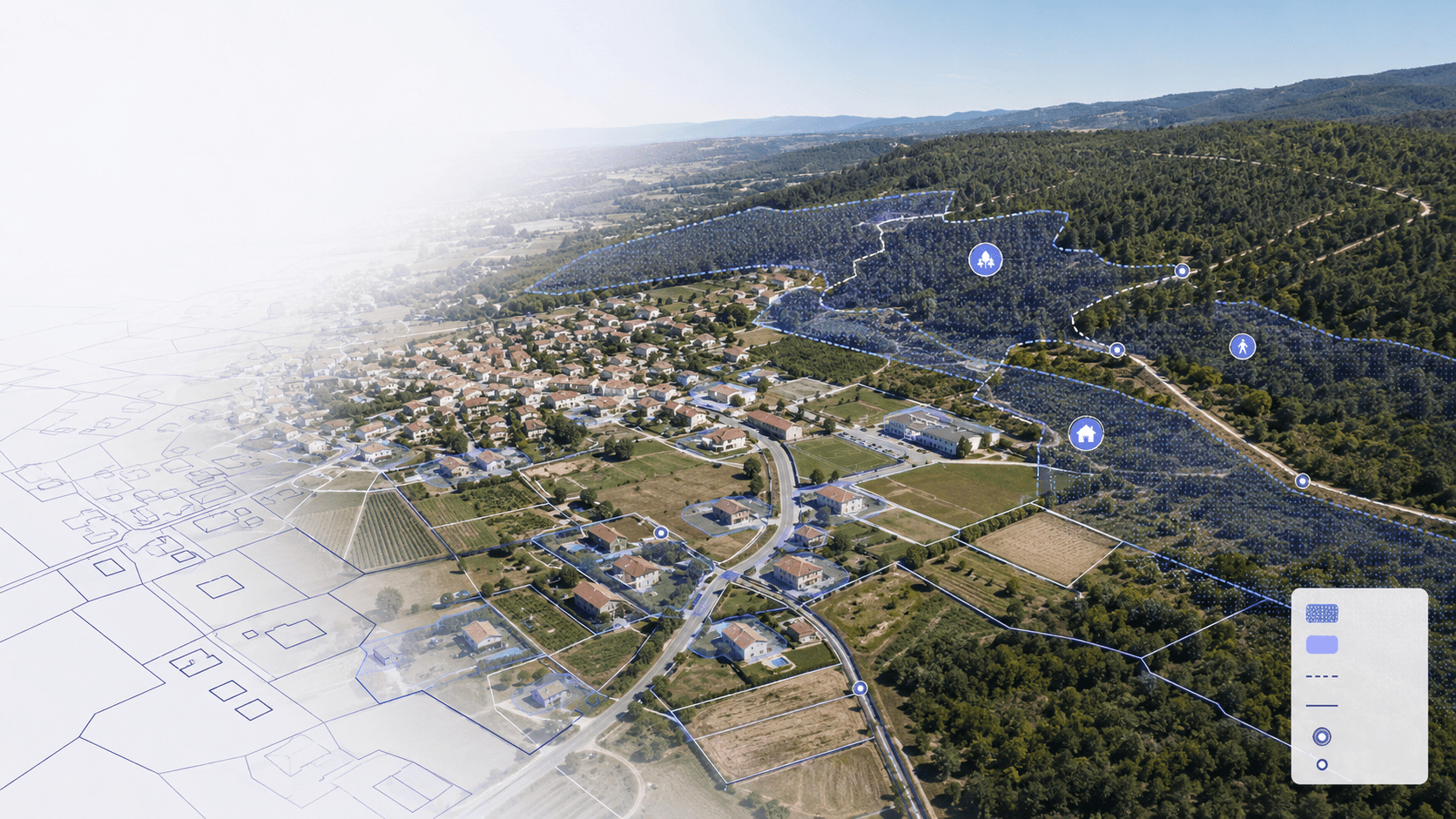
Mapping legal brush clearing obligations precisely allows for linking regulatory zoning, cadastral data, buildings, access routes, and field observations.
What are legal brush clearing obligations?
Brush clearing includes operations intended to reduce plant fuels in order to decrease the intensity of fires and limit their spread, in accordance with Article L. 131-10 of the Forest Code.
Therefore, it does not necessarily mean removing all vegetation. As Géorisques points out in its presentation on legal brush clearing obligations, brush clearing is neither clear-cutting nor land clearing.
The objective is to limit vegetation continuity between grass, shrubs, trees, and buildings. The work may notably include removing vegetation, pruning retained trees, or processing cutting residues.
The precise terms applicable locally are defined by prefectural decrees. They may set requirements regarding distances between vegetation, pruning, hedges, cutting residues, or access routes.
Which lands are affected by OLDs?
Legal brush clearing obligations apply in the territories covered by the Forest Code and decrees issued at the departmental level.
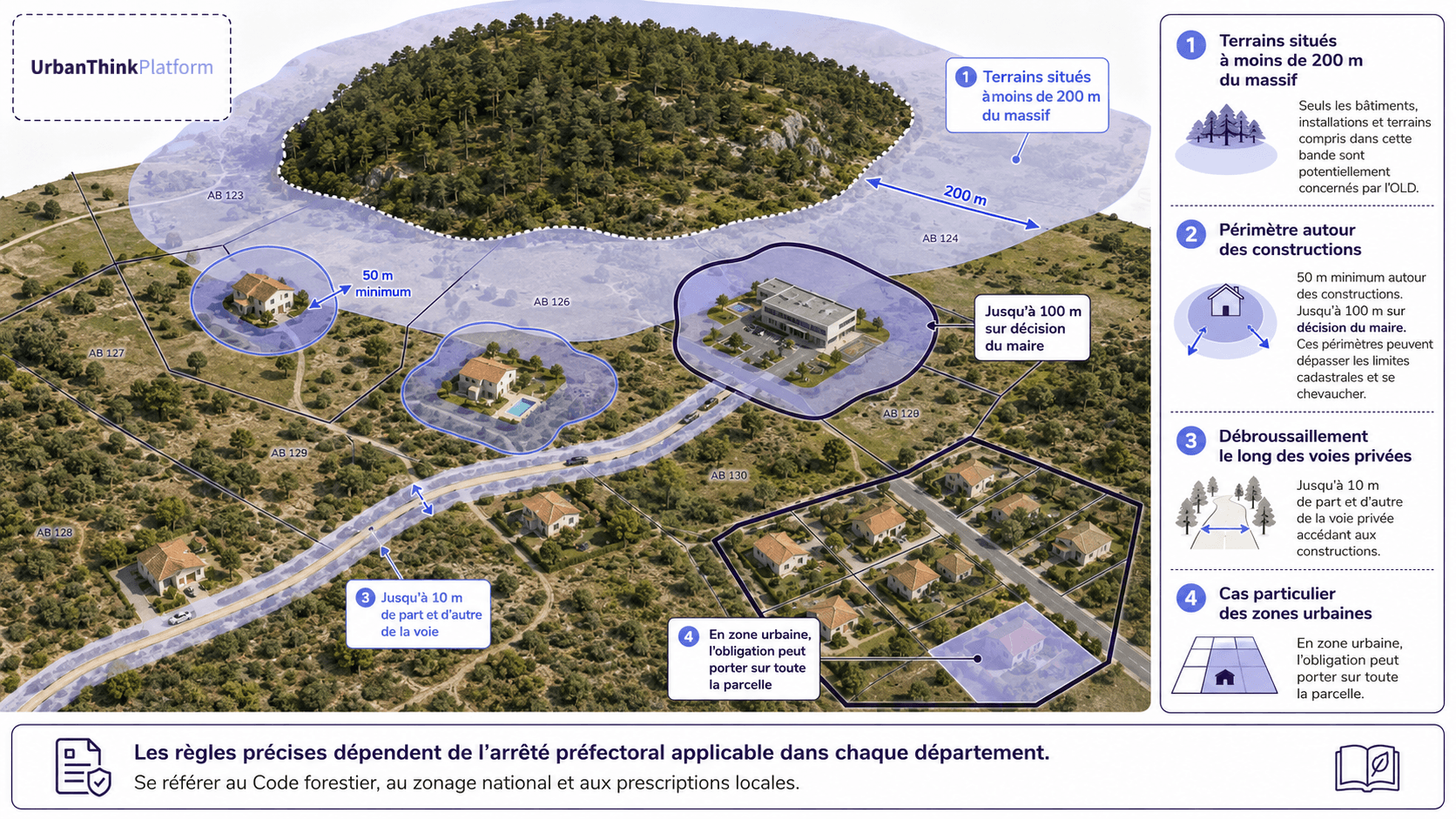
The obligation notably concerns certain lands located within 200 meters of woods, forests, heathlands, maquis, and garrigues exposed to fire risk, according to Article L. 134-6 of the Forest Code.
Around buildings, construction sites, and installations, brush clearing must generally be carried out to a depth of 50 meters. This distance can be increased to 100 meters by decision of the mayor, under the conditions provided for by the same Article L. 134-6 of the Forest Code.
Private roads providing access to buildings may also be affected. The clearing width is set by the prefect, up to a limit of 10 meters on either side of the road, in accordance with Article L. 134-6 of the Forest Code.
In certain urban areas defined by a local urban plan, the obligation may apply to the entire plot of land and not just the immediate surroundings of a building. Owners must therefore systematically consult the prefectural decree applicable to their department, in addition to the national informative zoning.
Why is monitoring OLDs complex for a municipality?
The mayor ensures compliance monitoring for certain brush clearing obligations provided for by the Forest Code, in accordance with Article L. 134-9 of the Forest Code.
In the event of non-compliance with the obligation, the applicable procedures may include a formal notice, an administrative fine, or the automatic execution of the works under the conditions provided for by the regulations. The rules and responsibilities applicable to owners are presented by Service-Public.fr.
To organize a monitoring campaign, local authorities must notably be able to answer the following questions:
Which parcels are located in an area subject to OLDs?
Which buildings generate a brush clearing obligation?
Does the scope of work exceed the property boundaries?
Which owners or occupants must be informed?
Which parcels have been inspected?
What non-compliances were observed?
What reminders or interventions need to be scheduled?
When this data is scattered across cadastral files, static maps, Excel spreadsheets, mail, and field reports, consolidating them quickly becomes difficult.
The mapping of OLDs is provided for by the Forest Code
The geographic representation of legal brush clearing obligations is not merely a communication medium.
Article L. 131-16-1 of the Forest Code provides that the boundaries of the lands affected by brush clearing obligations must be represented in one or more graphic documents. These documents must be annexed to the local urban plan, the urban planning document taking its place, or the municipal map.
This obligation strengthens the role of geographic data in fire prevention. However, a regulatory graphic document is not always sufficient to organize the daily work of municipal services.
Operational mapping makes it possible to link the regulatory perimeter to parcels, buildings, access routes, sent letters, and inspections carried out.
Moving from regulatory zoning to operational mapping
Géorisques provides mapping data for the informative zoning of OLDs (legal brush-clearing obligations). This data is available in Shapefile format, by department, to enable its use in a geographic information system.
Informative zoning is a useful basis for identifying areas to analyze. However, it must be supplemented by the requirements of the prefectoral decree, the characteristics of the buildings, and the assessments made on the ground.
Cross-referencing zoning with the cadastre
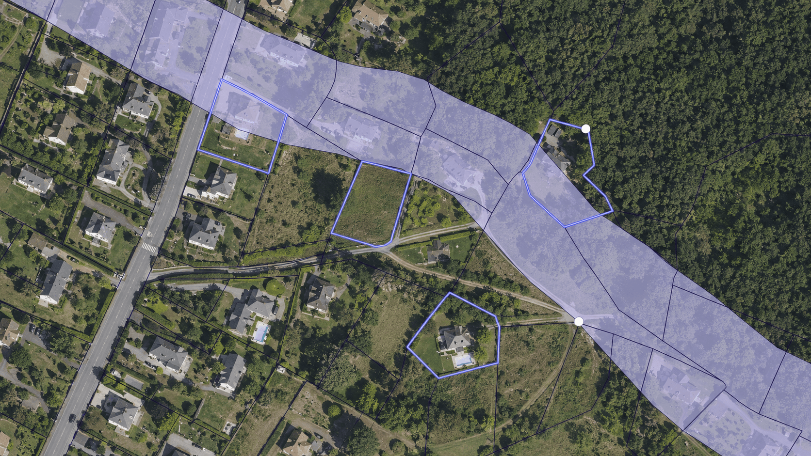
Superimposing the OLD zoning and the cadastral parcels makes it possible to identify properties located, in whole or in part, in the targeted areas.
This analysis can help services produce:
A list of parcels to qualify
An estimate of the areas included in the zoning
A breakdown of the challenges by neighborhood or sector
A map of priority parcels to examine
A basis for preparing information letters
However, the presence of a parcel in an informative zoning does not, on its own, determine the applicable obligation. The community must also take into account the existing buildings, the regulatory distances, and the departmental rules.
Locating buildings and installations
Locating buildings allows representing the brush-clearing perimeters around buildings, in compliance with the distances provided for by Article L. 134-6 of the Forest Code.
The mapping can integrate several categories of assets:
Dwellings
Public facilities
Establishments open to the public
Campsites and tourist accommodations
Agricultural or industrial buildings
Technical equipment
Isolated facilities near a forest area
This visualization facilitates the identification of parcels crossed by brush-clearing perimeters and any potential encroachments on neighboring lands.
Identifying encroachments on neighboring properties
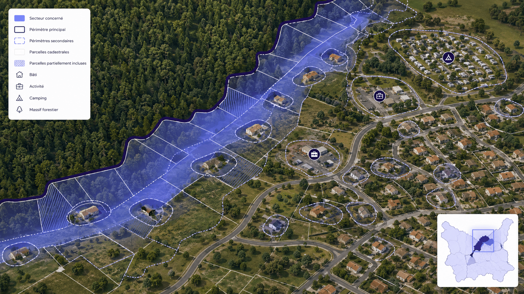
The brush-clearing perimeter may extend beyond the property on which a building is located. The rules of responsibility, informing the neighbor, and accessing the land are governed by Article L. 134-7 of the Forest Code and are presented in an accessible manner on Service-Public.fr.
Mapping makes it possible to identify these situations before sending letters or planning field visits.
However, it remains an analysis support tool. The determination of legal responsibility must be verified in light of the actual land ownership situation, the prefectoral decree, and the applicable laws.

Integrating access routes
Private roads providing access to buildings may be subject to a brush-clearing obligation, within the limits provided for by Article L. 134-6 of the Forest Code.
Integrating them into the mapping makes it possible to locate the affected access points, identify the sections to be checked, and find routes serving several buildings.
The national terms of brush-clearing work are specified in particular in the decree of March 29, 2024 relating to legal brush-clearing obligations. They are supplemented by the locally applicable departmental regulations.
Using mapping to prioritize actions
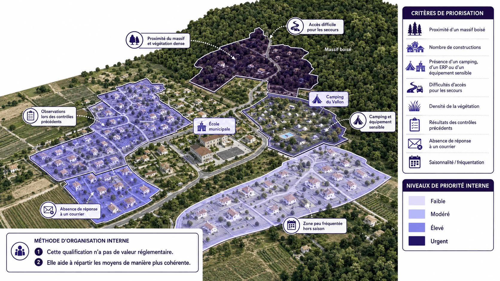
Prioritizing actions is not a regulatory obligation. It is an organizational method that local authorities can adapt to their territory.
UrbanThink recommends, for example, combining several criteria to prepare awareness and control campaigns:
Proximity to a wooded area or dense vegetation
The number of constructions present in an area
The presence of a campsite, a public-access building (ERP), or sensitive equipment
Access difficulties for emergency services
The apparent density of the vegetation
The results of previous controls
The lack of response to an information letter
The seasonality and visitor numbers of the sector
Each parcel or group of parcels can then be assigned an internal priority level: low, moderate, high, or urgent.
This classification has no regulatory value. It simply helps services allocate their resources more consistently.
Associating a tracking sheet with each parcel
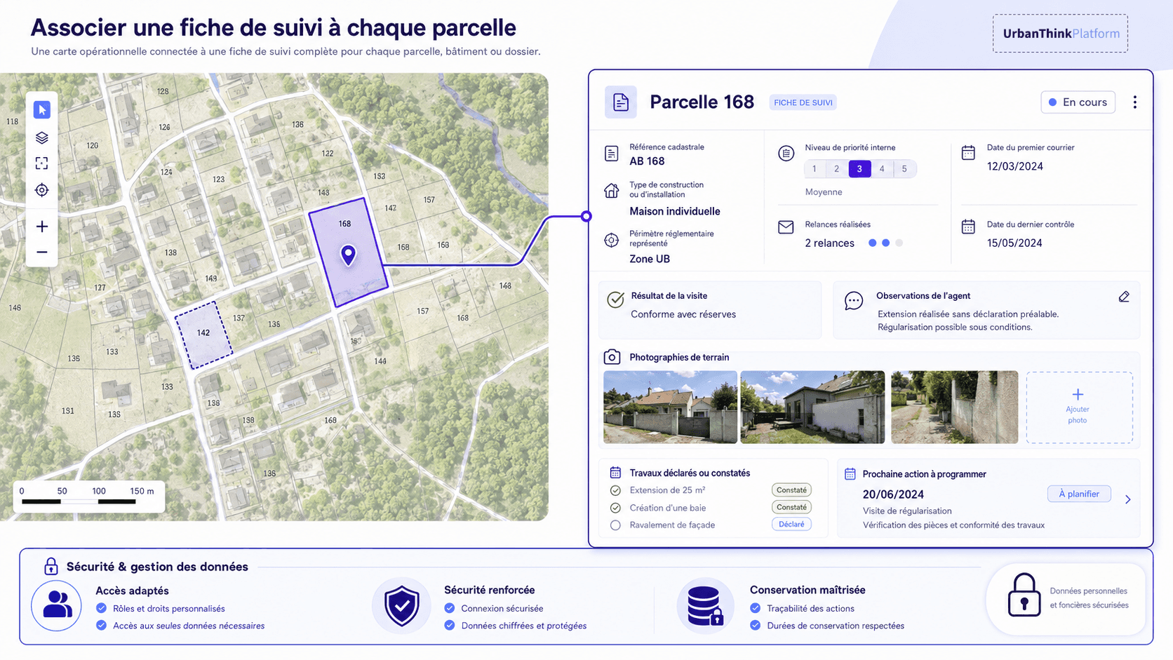
An operational map becomes more useful when it is linked to a tracking sheet per parcel, building, or file.
This sheet may contain:
The cadastral reference
The type of construction or installation
The represented regulatory perimeter
The internal priority level
The date of the first letter
The follow-ups carried out
The date of the last control
The result of the visit
The officer's observations
Field photographs
The declared or observed work
The next action to be scheduled
Personal and land registry data must be processed with appropriate access rights, controlled retention, and security measures proportioned to the information handled.
Better informing property owners
A personalized map can make it easier for owners to understand their obligations. In particular, it allows visualizing the parcel concerned, the building at the origin of the obligation, the theoretical clearing perimeter, the access roads, and any encroachments onto neighboring properties.
This map can accompany an information letter, be used during a public meeting, or serve as supporting material during office hours at the town hall.
Since January 1st, 2025, sellers and landlords of real estate located in an area subject to clearing obligations (OLD) must inform buyers or tenants of this obligation right from the real estate listing and in the environmental risk assessment, as indicated by Service-Public.fr.
However, the mapping representation must remain informative and refer to the applicable prefectural decree, which specifies local obligations.
What role for ThinkCities ?
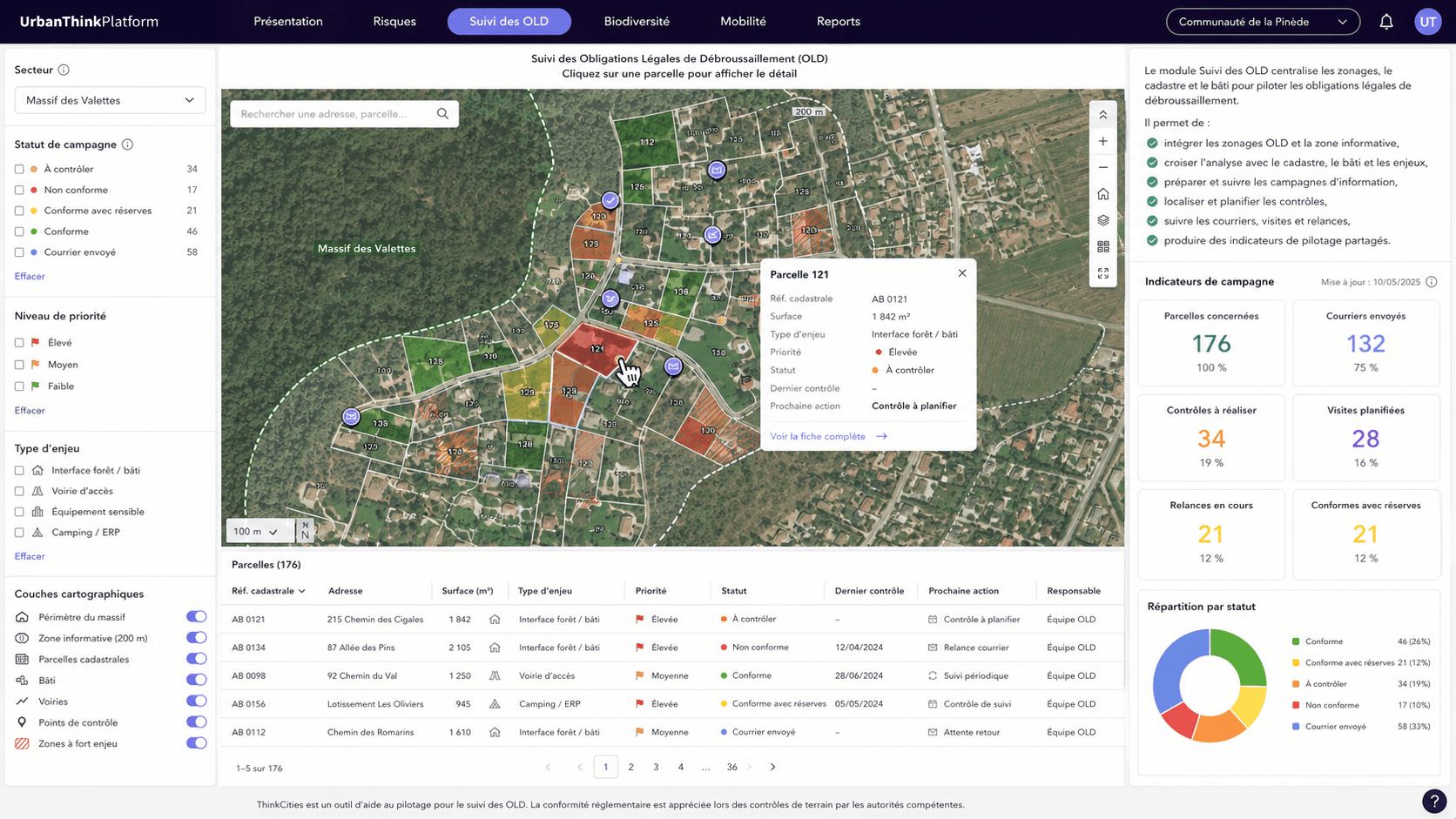
A local digital twin can bring together in a single interface regulatory zoning, cadastral parcels, buildings, access roads, environmental data, field observations, and initiated actions.
The platform ThinkCities by UrbanThink can help local authorities cross-reference, visualize, and update this information at the scale of a municipality or an intercommunality.
Within the framework of tracking clearing obligations (OLD), ThinkCities can notably facilitate:
Integrating the informative zoning of clearing obligations (OLD)
Cross-referencing with the cadastre and buildings
Preparing information campaigns
Locating controls to be carried out
Tracking letters, follow-ups, and visits
Producing steering indicators
Sharing a common vision between elected officials and departments
These features represent possible uses of the platform. ThinkCities does not automatically determine the regulatory compliance of a parcel: this assessment is the responsibility of the Forest Code, the applicable prefectural decree and, when necessary, a field inspection.
From regulatory map to municipal action plan
Mapping legal clearing obligations makes it possible to link three complementary levels:
Regulatory zoning, which identifies the areas concerned
Mapping analysis, which identifies parcels, buildings, and potential challenges
Field inspection, which allows assessing the actual situation and taking appropriate follow-up actions
By centralizing this information, local authorities can better organize their forest and vegetation fire prevention campaigns, improve information for owners, and track the progress of actions on their territory.
UrbanThink supports municipalities and intercommunalities in integrating regulatory, cadastral, and environmental data. Discover how ThinkCities can help local authorities visualize and manage their territorial data.