


Climate vulnerability study of a coastal campsite
A multi-risk climate vulnerability study carried out for an outdoor hospitality facility located on the coast: marine submersion, flooding, and vegetation fire, including mapping of exposed areas and recommendations for adapting the site.
Client:
Camping
Project type:
Climate vulnerability
Date:
2025
Localization:
Billiers, Morbihan
In a context of intensifying climate hazards in coastal areas, a campsite located on the coastline commissioned UrbanThink to carry out a climate vulnerability study of its site.
The objective was to assess the establishment’s exposure to several natural risks—marine submersion, flooding, and vegetation fires—in order to inform site planning, prevention, and safety decisions.
Issue
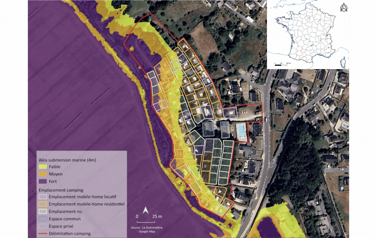
The studied site accommodates a large number of pitches in an environment exposed to several natural hazards. Located near low-lying areas and natural runoff paths, it shows particular sensitivity to rising water levels and flooding.
The presence of vegetated areas around the site also requires heightened vigilance regarding vegetation fire risk.
Our approach
UrbanThink deployed a multi-scale cartographic analysis of the site and its immediate surroundings.
For marine submersion, the study relied on topography, reference elevations, and sea-level rise projections, with several forward-looking scenarios up to 2100.
In addition, the analysis incorporated flood risk linked to the local hydrological context, as well as a vegetation fire risk assessment based on the nature of vegetation cover, soil moisture, and the identification of areas requiring heightened vigilance.
Results
The study highlighted a marked vulnerability of the site to the risk of marine flooding, with a significant share of the area and locations exposed under the scenarios examined.
The analysis also made it possible to formalize several operational recommendations, including:
adapting uses according to the level of hazard,
identifying priority zones to secure,
defining an evacuation plan to a refuge area,
improving water management on the site,
strengthening vigilance around vegetated surroundings.
Benefits
Thanks to this study, the operator now has a clear and documented analytical foundation to:
objectively assess its exposure to climate hazards,
prioritize the site’s sensitive areas,
guide its future planning choices,
strengthen user safety,
engage in a more structured dialogue with its partners and institutional stakeholders.

