Apr 16, 2026
Green Fund 2026: in which cases can mapping be funded by a local authority?

Renewed in 2026 with a budget of €837 million, the Green Fund confirms its role as a major lever to accelerate the local ecological transition. Since its creation in 2023, it has already supported 25,000 projects led by local stakeholders, for a total of €4.5 billion in grants, with a funding logic focused as closely as possible on the territories. The scheme remains structured around three pillars — environmental performance, adaptation to climate change and improvement of living conditions — and relies on decentralized management by prefects, with applications submitted via Aides-territoires and the Démarche numérique tool.
In 2026, the signal is very clear: adaptation to climate change becomes a priority, with a particular emphasis on flood prevention. The guide intended for local decision-makers specifies that this pillar now represents a central part of the Green Fund, and that the 2026 priorities primarily concern adaptation actions, flooding, energy-efficient renovation of buildings and land-use restraint. The Green Fund is also presented as the preferred tool for financing projects included in local ecological planning documents, such as PCAETs, CRTEs or the roadmaps resulting from regional COPs.
It is in this context that a question often comes up among local authorities: can a map be funded? The answer is yes, but under one essential condition: the map must not be seen as a standalone deliverable. It must be part of an eligible measure, address a concrete territorial issue and serve to improve knowledge, objectify a vulnerability, prepare a strategy or prioritize actions. In other words, the Green Fund does not finance a map “just to produce a map”; it finances mapping when it becomes a tool to support local public decision-making.
There is no general list of “eligible cities”
This is an important point to clarify from the outset. The 2026 guide does not present a general list of cities that would be eligible “by principle” for mapping. Eligibility depends on the measure used, the type of territory, the project lead and the direct link between the mapping and a funded action. A municipality, an intermunicipality, a mixed syndicate or another local contracting authority may therefore be concerned, but only if its project falls within the framework of an open Green Fund measure.
First very concrete case: municipalities and intermunicipalities facing flood risk
The first major case in which a map can be funded concerns flood prevention. The guide specifies that the 2026 Green Fund intervenes for actions that are not eligible for the Barnier Fund, especially when there is no PPRN in the area or when the other rules for mobilizing this fund do not allow the action to be financed. Supported projects may focus on improving knowledge of the risk, particularly of runoff phenomena, on vulnerability assessments and on works to reduce the vulnerability of public buildings. Eligible applicants are local authorities or their groupings, acting as the project owner for prevention or protection studies and actions.
This means that a municipality can have a map financed when it is used to locate exposed areas, understand runoff, rank vulnerable public buildings or prepare a vulnerability-reduction program. The guide even adds that in 2026, the Green Fund will specifically help rural municipalities exposed to flood risk, not covered by a PAPI, by supporting the reduction of the vulnerability of their public buildings. For these authorities, mapping becomes a very practical tool to objectify priorities and build a solid application.
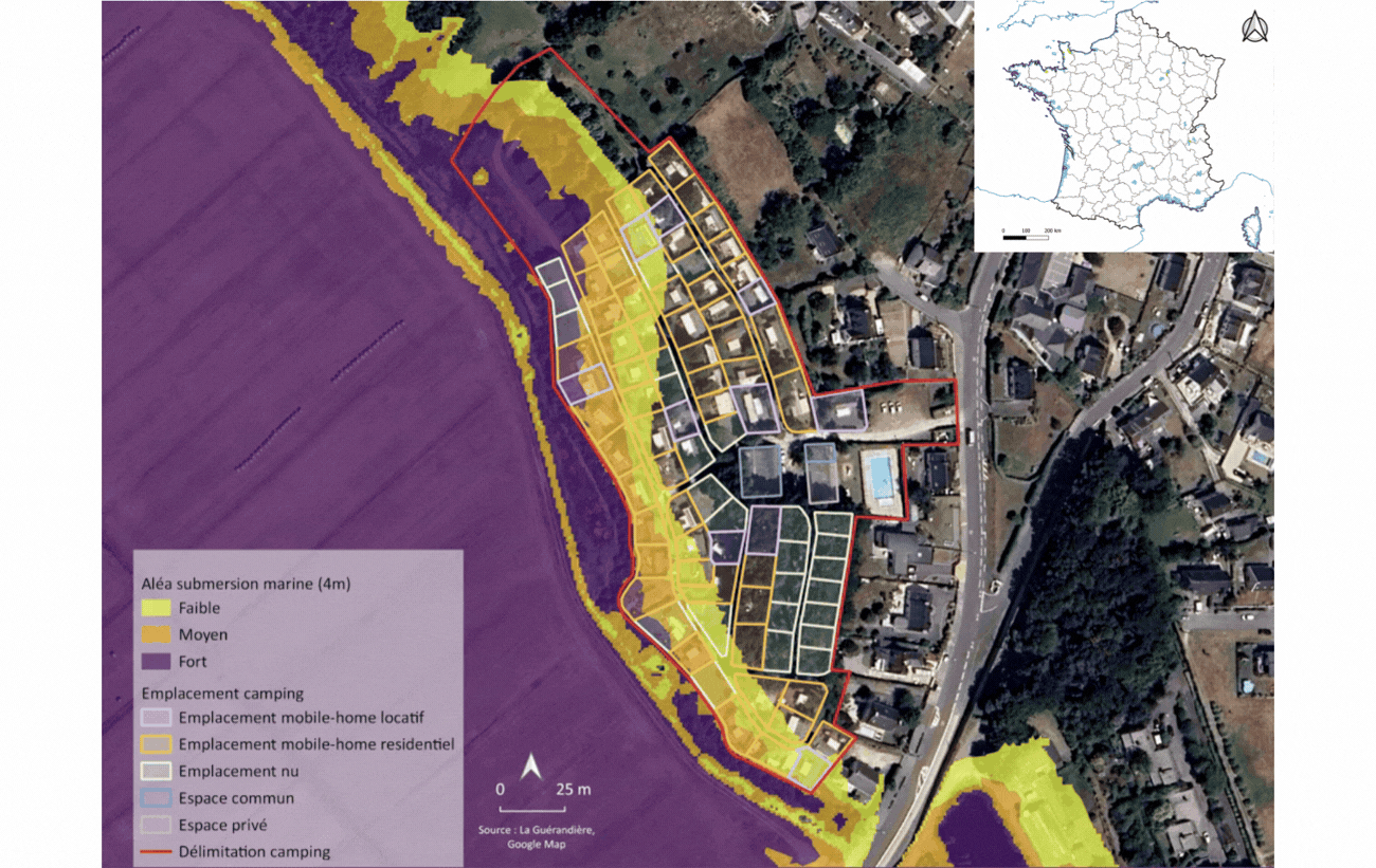
Second very explicit case: coastal municipalities affected by shoreline retreat
The clearest case in the 2026 guide is that of the adaptation of coastal areas to shoreline retreat. There, the Green Fund explicitly co-finances the development of shoreline observatories, local shoreline retreat projection maps, local integrated management strategies, prefiguration studies to initiate spatial reconfiguration, as well as certain soft-management and reconfiguration actions. The guide also mentions adaptation or relocation works for open-air hotel facilities directly affected by shoreline retreat, which makes this measure particularly important for coastal tourist municipalities.
But here, territorial eligibility is more targeted. The text states that the measure concerns the local authorities listed in the decree whose urban planning action and land-use policy must be adapted to shoreline retreat. It also specifies that in 2025, two-thirds of the funding for this measure was used to support the preparation of local exposure maps. In short, a coastal municipality is not eligible simply because it is located by the sea: it must fall within the targeted regulatory scope and integrate its mapping into a logic of knowledge, local strategy or reconfiguration.

Third case: municipalities and groupings that carry a municipal biodiversity atlas
Another major development in 2026: the Green Fund includes a measure dedicated to biodiversity, entitled “Acting for biodiversity: from municipal biodiversity atlases to nature restoration”. This measure notably funds ABCs, which are presented as decision-support tools for municipalities, their groupings, mixed syndicates and national parks. The guide explains that they make it possible to establish territorial diagnoses, action plans and, above all, a mapping of biodiversity issues in the territory of the project holder.
Here, mapping is not a secondary support: it is at the very heart of the measure. It becomes eligible for funding because it helps better understand local biodiversity, inform public decision-making and structure territorial action. This is an interesting case for local authorities that want to better integrate biodiversity into their urban planning, land-use planning, management of natural areas or environmental choices.

Fourth case: urban renaturation projects
The 2026 Green Fund can also finance mapping as part of the measure Renaturation of towns and villages. The guide specifies that eligible applicants are the project owners of projects located in urban areas, in particular local authorities, their groupings, local public bodies or state public bodies, as well as social landlords. Eligible actions may include territorial and strategic diagnostics, preliminary project design studies or investments, provided that they contribute to soil renaturation, the presence of water, or the greening of buildings and public facilities.
Concretely, this opens the way to maps that serve to document heat islands, impervious areas, sectors with potential for de-sealing, issues related to the presence of water or priority greening. Once again, the logic remains the same: mapping is only eligible for funding if it sheds light on an adaptation, renaturation or vulnerability-reduction project.

A broader logic: upstream engineering for projects
The Green Fund also provides engineering support, intended to help project holders identify needs and solutions upstream, secure their projects from the design stage and support them through to evaluation. This component is important because it can make it possible to finance part of the preparatory work when mapping is used to frame a project, document a diagnosis, prepare a local strategy or structure a funding request. The guide also highlights this support logic, while noting that various public organizations such as ANCT, Cerema, Ademe, OFB, water agencies, ATD or CAUE can contribute to this support.

Why some maps are fundable and others are not
The decisive criterion is therefore not only the nature of the geographic data. What matters is the public purpose of the map. It becomes fundable when it makes it possible to better understand a risk, characterize exposure, locate vulnerabilities, support a local strategy, or prepare works and investments consistent with the priorities of the Green Fund. This is precisely why the measures most favorable to mapping are now those related to floods, the coastline, biodiversity, renaturation and, more broadly, to upstream engineering.
What this changes for local authorities
For elected officials, technical departments and project managers, the real issue is therefore not just “can we fund a map?”, but rather: what territorial project does this mapping make it possible to build? A funding request will be all the stronger if it clearly shows the link between the data produced, the local problem to be addressed, the actions envisaged and the territory’s strategy. A vulnerability map is not worth the same as a descriptive map; it becomes much more relevant when it makes it possible to justify prioritization, phasing, a works program or an adaptation trajectory.
The role of UrbanThinkPlatform
This is precisely where an approach like that of UrbanThinkPlatform makes perfect sense. A local authority does not need one more fixed map. It needs a decision-support map, capable of cross-referencing hazards, buildings, uses, facilities, regulatory constraints and investment priorities. Under the Green Fund 2026 framework, the value is not in the map itself, but in its ability to turn a local need into a fundable project, consistent with the open measures and readable for the reviewing departments. In the end, a map truly becomes fundable when it helps the local authority answer four simple questions: where to act, why act there, what to protect, and with what logic of adaptation
Are you wondering whether your mapping can be funded through the Green Fund 2026?
The answer depends less on the map itself than on how it is structured and integrated into a territorial project.
UrbanThink offers you a quick exchange to:
analyze your need,
identify the funding levers that can be mobilized,
and tell you concretely whether your project can fit within the Green Fund framework.
👉 Book a time slot with our team:
Schedule a meeting