Oct 24, 2025
With the digital twin, transforming data into decision

What if we could anticipate the changes of a site, a city, or a real estate asset before they occur?
This is no longer a science fiction scenario: it is today an operational reality thanks to the digital twin.
Far from being a technological gadget, the digital twin is becoming a strategic lever for ecological, energy, and territorial transition.
It connects data, modeling, and decision-making, moving from a static vision to an action driven by facts.
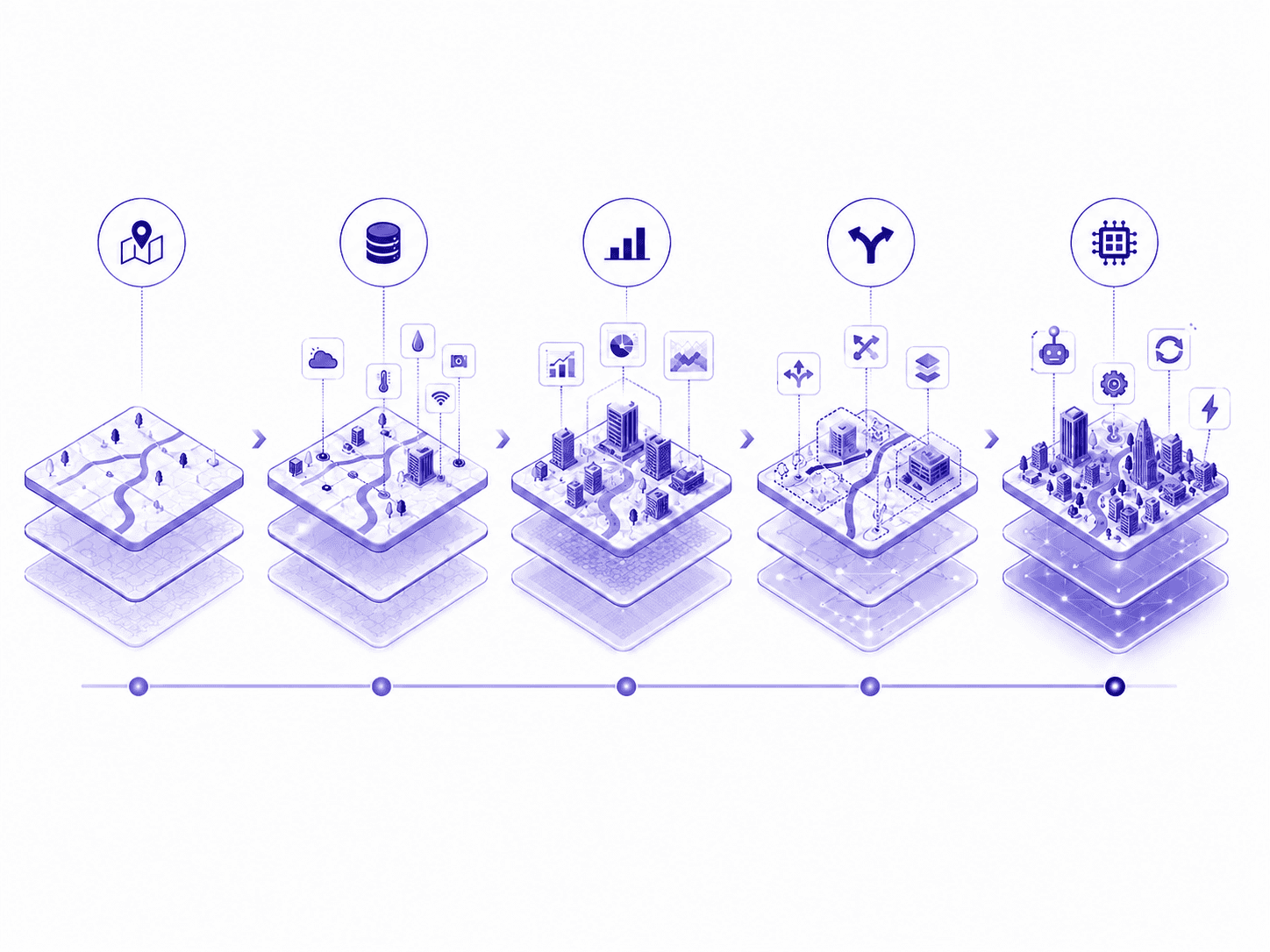
What is a digital twin?
A digital twin is the virtual replica of a real asset: a city, a neighborhood, a building, a port, a campsite, or even a network of infrastructures.
Its objective: to observe, simulate, and anticipate the behavior of the real based on constantly updated data.
Three fundamental components make it operational:
The data: they come from multiple sources — sensors, energy consumption, mobility indicators, biodiversity assessments, climate data, etc.
Modeling and simulation: based on this data, the twin calculates scenarios of evolution — for example, the impacts of a heatwave on electricity consumption or a development on biodiversity.
Visualization: the user accesses maps, 3D models, and dashboards that translate thousands of data points into clear and actionable indicators.
The result is an interactive, living, and evolving environment that faithfully reproduces the functioning of the real while allowing the testing of the consequences of a decision before its implementation.
What is the purpose of a digital twin?
The digital twin transforms raw data into decision-making intelligence.
It is a cross-functional tool that meets the needs of a mayor, a technical director, or an asset manager as well as those of an energy provider or an investor.
Its uses are divided into four main functions:
🔎 Anticipate
Identify climatic, social, economic, or regulatory risks.
Virtually test different urban developments, energy plans, or public policies before their actual deployment.
Simulate the impact of hazards like floods, heat islands, or rising energy costs.
⚙️ Decide
Compare several quantified scenarios and assess their effects in the short, medium, and long term.
Prioritize actions based on their effectiveness, cost, and contribution to decarbonization.
Build a realistic energy or ecological trajectory based on tangible data.
♻️ Optimize
Reduce energy and water consumption by identifying efficiency gains.
Plan works and investments where they have the greatest impact.
Share resources (lighting, heat, networks) to enhance collective performance.
🌍 Enhance
Increase the resilience and attractiveness of an asset, a territory, or an organization.
Strengthen the credibility of environmental commitments with investors, institutional partners, or citizens.
Communicate progress more easily thanks to verifiable and transparent data.

From concept to reality: the concrete uses of the digital twin
The digital twin is no longer a futuristic idea: it is already deployed on the ground.
At UrbanThink Platform, it applies to both territories and strategic private sites.
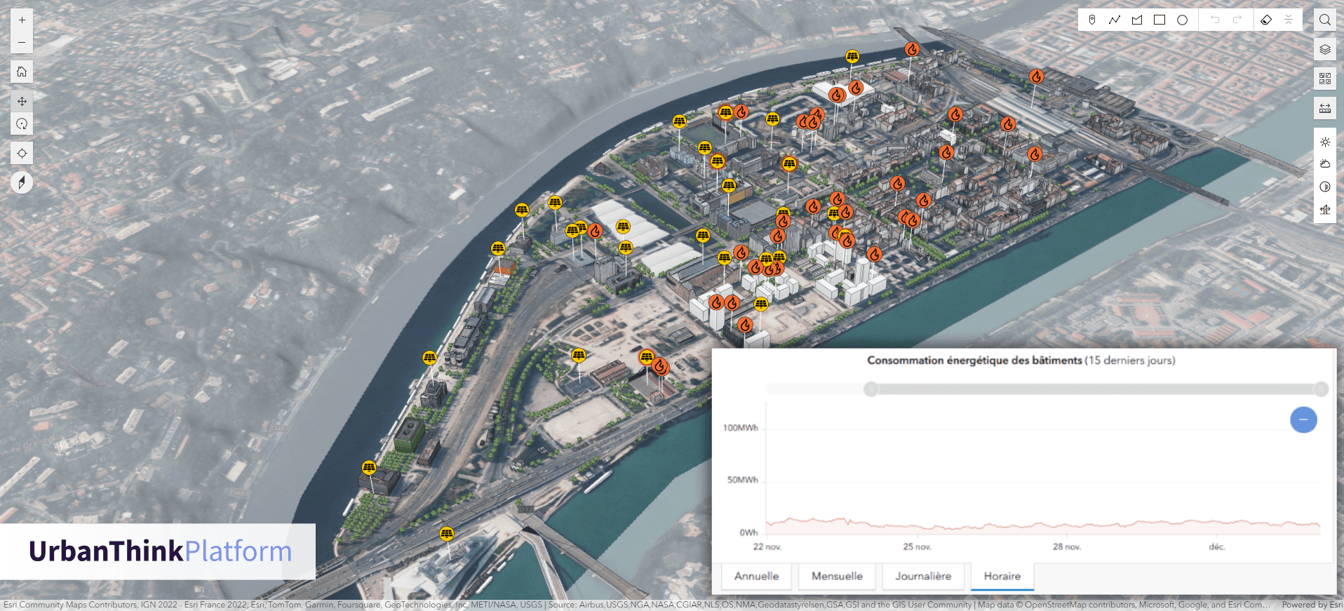
Example: Lyon Confluence
In Lyon, a positive energy district is monitored in real-time via a digital twin developed in partnership with UrbanThink.
This system aggregates and visualizes:
the production and consumption of energy,
the daily mobility,
the biodiversity and the quality of public spaces.
Decision-makers can thus steer their energy transition, adjust their public policies, and target the most effective investments.
The twin then becomes the integrated dashboard of urban resilience, at the intersection of ecology, digital technology, and local governance.
Why the digital twin is becoming essential today
Public and private organizations must deal with an unprecedented combination of pressures:
Climate change and the multiplication of hazards (floods, heatwaves, droughts).
Energy sobriety imposed by regulations and rising prices.
Land artificialization and pressure on resources.
Decarbonizing mobility and evolving urban uses.
Strengthening the regulatory framework (Tertiary Decree, ZAN, CSRD, Green Taxonomy, etc.).
Increased demand for transparency and performance from citizens, users, and investors.
In the face of these challenges, decision-makers can no longer settle for Excel spreadsheets or static plans.
They need a systemic, connected vision capable of linking environmental, economic, and social indicators.
The digital twin precisely meets this requirement: it connects data, territories, and decisions

Perspectives: Towards Multi-Theme Digital Twins
If the first digital twins focused on energy and networks, their scope is quickly expanding.
New themes are being integrated:
Biodiversity and ecological resilience: monitoring ecological continuities, green and blue networks, or the impact of developments on living organisms.
Adaptation to climate change: simulation of heat islands, management of rainwater, prioritization of shaded and greening areas.
Consultation and citizen participation: visualization of projects in immersive environments to strengthen local dialogue.
Low-carbon strategies: integration of GHG assessments, reduction trajectories, and emission factors.
Economic and territorial assessment: measuring the socio-economic impacts of sustainable investment policies.
Tomorrow, these multi-theme digital twins could become true “environmental cockpits”, capable of integrating the dimensions of energy, climate, biodiversity, mobility, water, and carbon within a single interface.
UrbanThink Platform: designing digital twins tailored to each context

At UrbanThink Platform, we design customized environmental digital twins that can integrate the realities, data, and challenges specific to each client.
Our approach is based on three pillars:
Aggregation and validation of data: automated recovery of energy, water, mobility, climate, and biodiversity data via sensors, APIs, and open sources.
Modeling and indicators: calculation of customized indicators (consumption, emissions, vulnerability, resilience) to support decision-making.
Interactive visualization: dynamic maps, 3D models, and dashboards tailored to each user profile.
These environments are already deployed in various projects:
port areas (energy and hydrological monitoring),
campgrounds and tourist sites (climate vulnerability and sustainable management),
urban neighborhoods (biodiversity, mobility, energy, carbon),
industrial and real estate sites (energy optimization and CSRD reporting).
🎯 The goal: to transform environmental data into concrete, measurable, and shared decisions.